The area northeast of Greenland
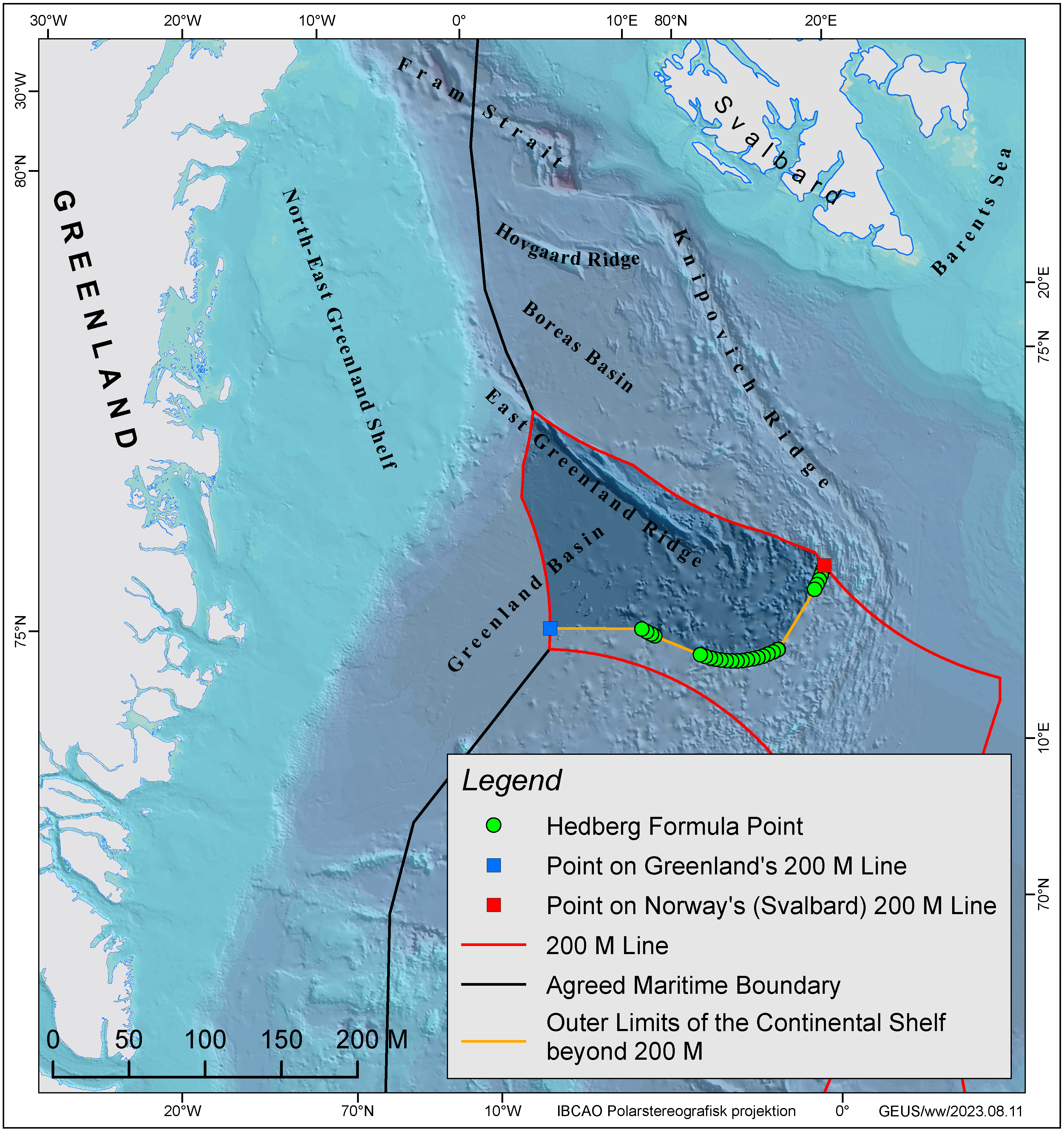
The area off North-East Greenland is confined by the exclusive economic zones (EEZ) of Svalbard (Norway) to the north, Jan Mayen (Norway) to the south and Greenland to the west. Since summer of 2002 three successful data acquisition projects have been carried out in the area off North-East Greenland in co-operation with Sweden and Norway among others:
- In 2002, researchers collected seismic reflection and refraction data using the Norwegian research vessel Håkon Mosby in co-operation with the University of Bergen.
- At the end of the LOMROG I expedition in 2007 with the Swedish icebreaker Oden, bathymetric and seismic data were acquired in North-East Greenland in co-operation with the Swedish Polar Research Secretariat.
- During the EAGER2011 cruise with the Swedish icebreaker Oden, detailed bathymetric data as well as seismic refraction and reflection data were acquired along the East Greenland Ridge.
In addition, dredge samples were taken from two locations along the flanks of the East Greenland Ridge during a scientific cruise with the Norwegian research vessel Helmer Hanssen in 2012.
On 26 November 2013, the Government of the Kingdom of Denmark together with the Government of Greenland submitted documentation for an extended continental shelf beyond 200 nautical miles northeast of Greenland to the Commission on the Limits of the Continental Shelf (CLCS). The area between Greenland and Svalbard (Norway) covers approximately 62,000 km2 beyond the 200 nautical mile limit of Greenland.
The scientific documentation, referred to as submission, was submitted via the Secretary-General of the UN in accordance with the procedure laid out in the 1982 United Nations Convention on the Law of the Sea, which was ratified by the Kingdom of Denmark in 2004. A state has the rights over the continental shelf within 200 nautical miles of its coast (also called the Exclusive Economic Zone). Claims beyond 200 nautical miles from the coast require special documentation, which is based on the acquisition of comprehensive scientific data sets.
The continental shelf beyond 200 nautical miles of Norway overlaps the claim of the Kingdom of Denmark off North-East Greenland. After examination by the CLCS, it will be up to the parties to negotiate a bilateral agreement for the areas with overlap.
Summary of the claim
An extract of the submission for the area northeast of Greenland (the Executive Summary) can be read here. The remainder of the submission is not publicly accessible.
The claimed area northeast of Greenland
The outer limits of the continental shelf in the area northeast of Greenland. The red lines are the 200 nautical mile limits of Greenland and Norway, respectively, while the black lines show the agreed boundaries with Norway.


