Rules for the extension of the continental shelf
According to Article 76 in the United Nations Convention on the Law of the Sea, a state may claim an extension of its continental shelf (legally) beyond 200 nautical miles, if the outer edge of the continental margin extends farther. In the stipulations of Article 76, the following two basic terms are used:
- A baseline is a starting point for determining e.g. the breadth of the territorial sea or the breadth of the Exclusive Economic Zone (EEZ). It is usually identical with the low-water line along the coast, but the Convention on the Law of the Sea has established rules on how to determine the baseline.
and
- The foot of the continental slope (FOS) is the point at the base of the continental slope with the largest change in gradient. If it is not possible to determine this, other methods may be used.
The outer edge of the continental margin may be determined using two different formulas
See Figure B.
- The Hedberg Formula: a line connecting points that are 60 nautical miles away from the foot of the continental slope.
- The Gardiner Formula, or the Sediment Formula: a point where the thickness of sediments below the seabed is a least 1% of the distance to the foot of the continental slope. That means that if the distance is 100 km from the foot of the slope, the sediments must have a thickness of at least one kilometre.
The resulting formula line is found by connecting a combination of points defined by the above formulas so that the line extending the continental shelf furthest possible can be used.
In order to delimit the extension of the continental shelf, two constraint lines are defined
See Figure C.
- The 350 nautical miles line (i.e. a line that is 350 nautical miles from the baseline) – the distance constraint line,
- The line that connects points, which are 100 nautical miles from the 2,500 metres depth contour – the depth constraint line.
Furthermore, there are special rules for submarine ridges. We distinguish between:
- Oceanic ridges that are not a part of the continental shelf.
- Submarine ridges where it is not possible to use the depth constraint line (100 nautical miles from the 2,500 m depth contour).
- Submarine elevations that are a natural component of the continental shelf and where it is possible to use the depth constraint line (100 nautical miles from the 2,500 m depth contour).
In order to determine the final delimitation line, the coastal state may combine the two constraint lines in such a way that the line furthest away from the baseline at a given point may be used.
The outer limit of the continental shelf is then determined by combining the formula and constraint lines in the following way: if the formula line is closer to the baseline than the constraint line, the formula line applies – otherwise the constraint line applies (see Figure D).
According to the Convention on the Law of the Sea, the final outer limit of the continental shelf is to be indicated by points connected to straight lines; each line must not be longer than 60 nautical miles.
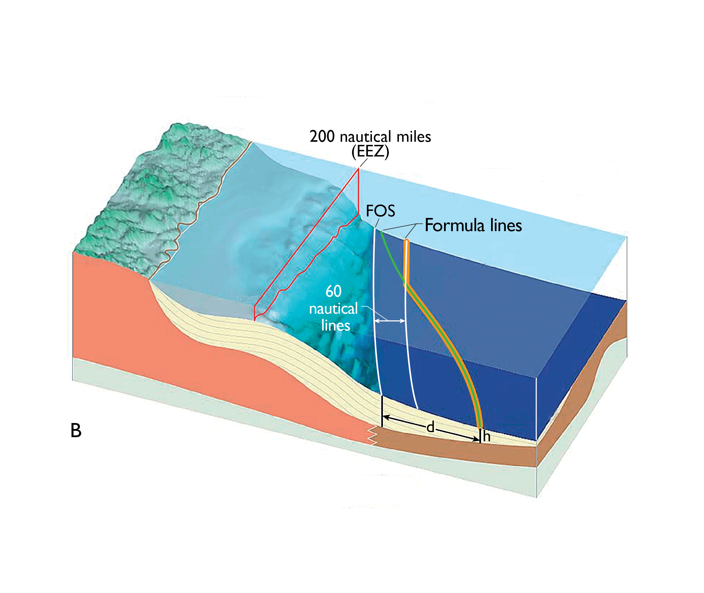
Figure B shows the two formula lines. The Hedberg line (white), which is 60 nautical miles from the foot of the continental slope, and the Gardiner line, or the sediment formula (green), where the thickness of the sediment (h) must be at least 1% of the distance (d) from the foot of the continental slope. The resulting formula line (orange) is found by combining the two formula lines.
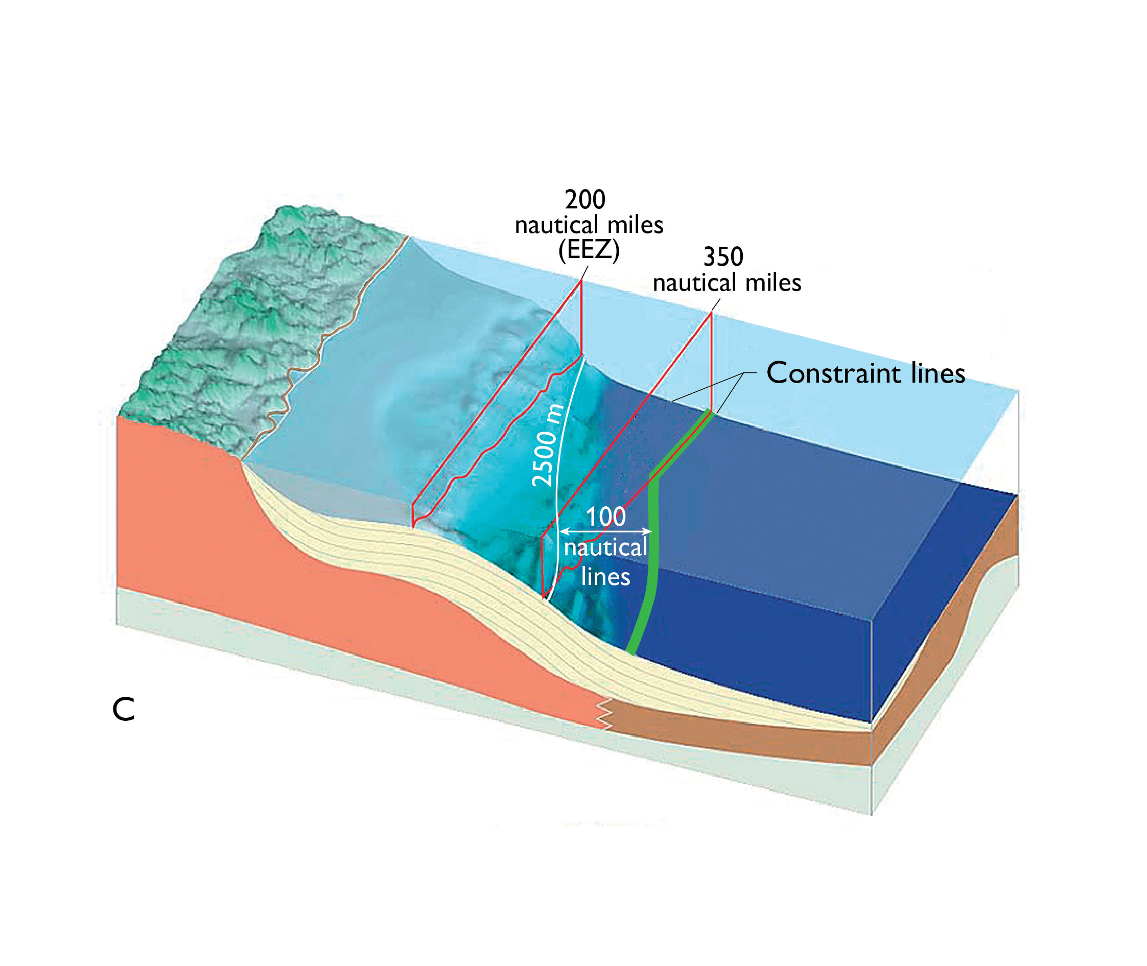
Figure C shows the two constraint lines: the 350 nautical lines line (red) and the line that is 100 nautical miles from the 2,500 metres depth contour. The resulting constraint line (green) is found by combining the two constraint lines.
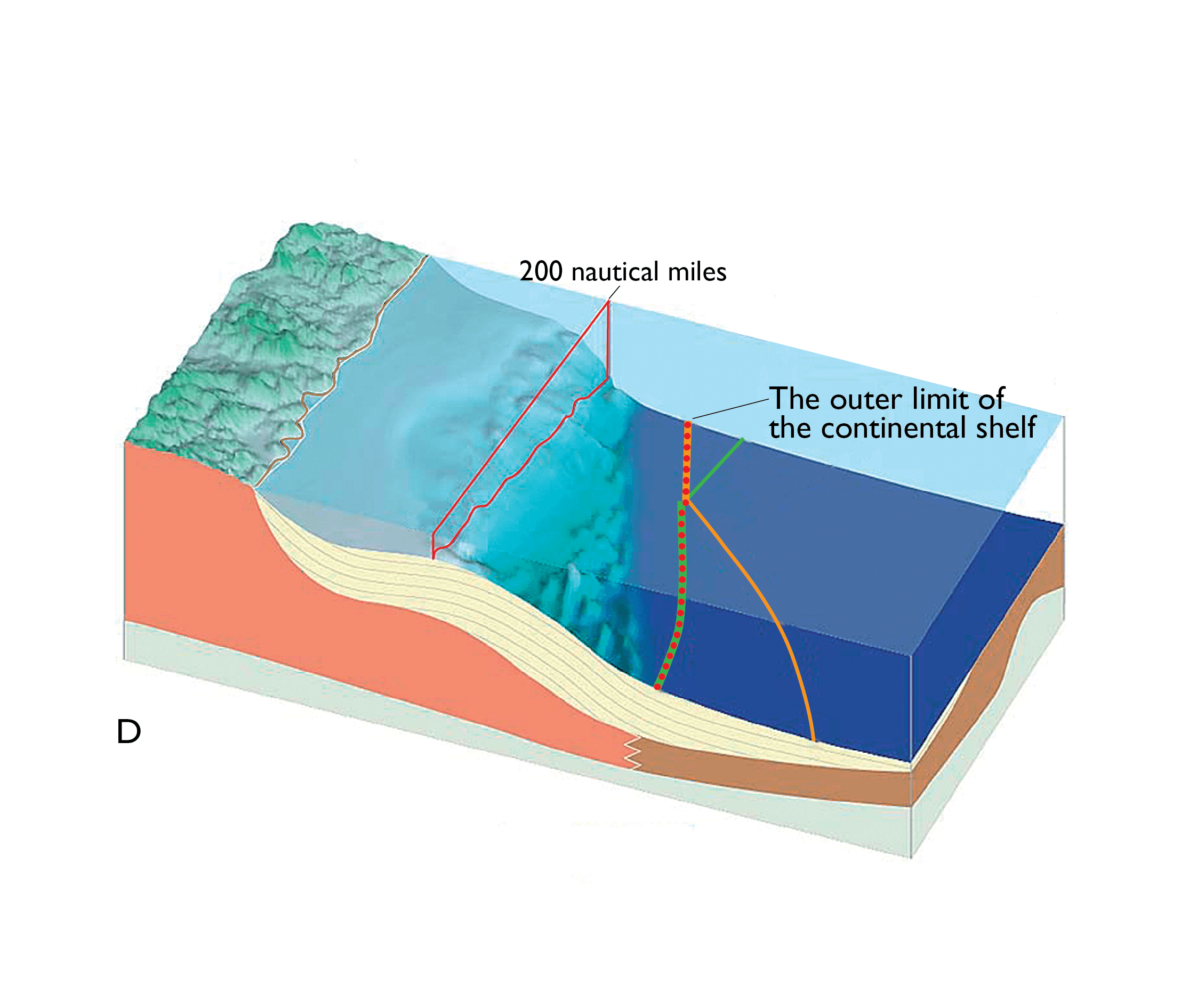
Figure D shows how the formula and constraint lines are combined in order to find the final outer limit for the continental shelf (the red dots). The outer limit is indicated by points connected to the right lines; each must not be longer than 60 nautical miles.