Cruise Report for EAGER 2011
The EAGER 2011 cruise (East Greenland Ridge) with the Swedish Icebreaker Oden was planned with the purpose of acquiring multibeam bathymetry (depth of water), sub-bottom profiles, seismic reflection and refraction profiles and gravity data in the area off North-East Greenland in connection with the Continental Shelf Project. The cruise was arranged in co-operation with the Swedish Polar Secretariat.
Project description
The multibeam bathymetric data acquisition focused on the mapping of the East Greenland Ridge and the continental slope of the North-East Greenland continental margin south of the ridge.
Multibeam bathymetry was collected continuously during EAGER 2011 with the SIMRAD EM 122 multibeam echo sounder installed on Oden in order to study bottom processes and seafloor morphology. This multibeam system operated with a frequency of 12 kHz and collected depth information over a swath width approximately five times the operating water depth. In addition, sub-bottom profiling was carried out continuously to characterise the upper approximately 50–200 m seafloor sediment stratigraphy using Oden’s hull-mounted 2-8 kHz chirp sonar system SBP 120.
The seismic data acquisition investigated how the East Greenland Ridge is attached to the North-East Greenland shelf. Seismic refraction investigations used both ocean bottom seismometers (OBS) and sonobuoys. Seismic reflection data were acquired using a short streamer (approx. 300 metres). The total length of the seismic profiles is about 280 nautical miles, with approx. 25 nautical miles in Norwegian waters.
The seismic source consisted of four G-gun’s, each with a chamber size of 520 cubic inch (total volume 2080 cubic inch). The four guns were arranged as two parallel clusters with one gun in each corner. The distance between each gun was approx. 90 cm. The towing depth of the gun array was from 6 metres to 20 metres below the water surface. During the seismic refraction measurements, the air guns were fired at a pressure of 3000 PSI every 60 sec., whereas only two air guns (total volume 1040 cubic inch) with a firing rate of 12 sec. were used during seismic reflection measurements.
Oceanographic sampling, including CTD and water collection, was carried out at dedicated hydrographic stations. Sound velocity data was used to calibrate the multibeam data. Gravity data were acquired during the entire EAGER 2011 cruise. Furthermore, a biochemical and an ornithological research project participated in the cruise.
You can find short field reports (in Swedish) on the Swedish Polar Secretariat’s website.
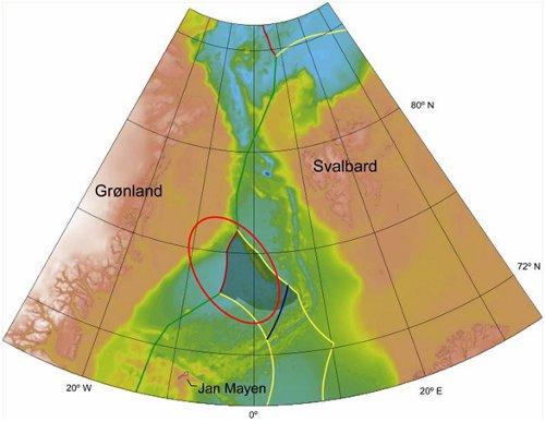
Map showing the Fram Strait and Greenland Sea. The working area for the EAGER 2011 cruise is shown by a red circle.